|
Mountain Architecture: An Alternative Design Proposal CHAPTER III PROGRAM FOR THE DESIGN
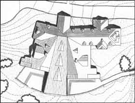
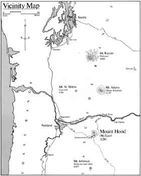
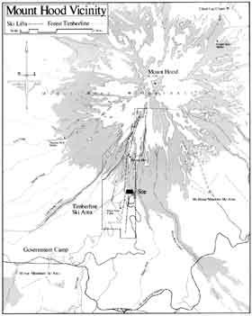
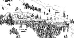
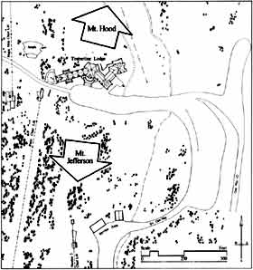
The facilities program, site selection criteria, and project goals presented below were drawn directly from two sources: the USDA Forest Service Environmental Statement, "Timberline Lodge", (the final, dated October, 1975), a 160 page document intended to address the "selection of a long term management direction for the Timberline Lodge complex"; (1) and a detailed facilities program for construction of the Wy'East Day Lodge as built, supplied by the U.S. Forest Service to the Portland architectural firm of Broom Oringdulph O'Toole Rudolf & Associates (BOORA). The technical requirements portion of the facilities program is reproduced in full as Appendix C. The Timberline Lodge Ski Area and Resort Complex is located sixty miles by car east of Portland Oregon, at an elevation of 6,000 feet on the southern slopes of Mount Hood, the highest mountain in the Oregon Cascades (Map 3.1). The Lodge itself is located right at the forest timber line, directly south of the summit (Figure 3.1; Map 3.2 ). The nearest town, Government Camp (population 300), is a long six miles away, at the beginning of an all-weather road kept open year around by the Oregon State Highway Department. Most visitors arrive at the Lodge from Portland via U.S. Highway 26 and can cover the distance in a little more than an hour. Together with U.S. 26, State Highway 35 (between Mount Hood and Hood River) and Interstate I-84 which runs along the Columbia River, constitute the "Mount Hood Loop". The Loop is a popular scenic drive, of which a sortie to Timberline Lodge is an essential part. Highway 26 is the primary east-west route between Portland and central Oregon giving excellent access to Timberline Lodge from all parts of the state. As an illustration of its accessibility, in 1975, over 700,000 people (including skiers) visited the Lodge. (2)
Downhill skiing in the Mount Hood vicinity is shared by five ski areas, including Timberline. Mount Hood Meadows Ski Area, opened in 1969 and now the largest, is the most popular, offering the greatest diversity of terrain. Multorpor and Ski Bowl, two older ski areas located at Government Camp, combined operations in recent years to become Mirror Mountain, the third largest area on the mountain after Mount Hood Meadows and Timberline. Another much smaller facility, catering mostly to beginners, is the Summit Ski Area, also located at Government Camp. Only one ski area, Cooper Spur, is located on the north side of Mount Hood. It is the smallest of the four major areas and draws skiers primarily from the town of Hood River and other points north. Timberline, as a ski area, is unique in this country. Nowhere else is quality downhill skiing available all year around. Glaciers on the south side of Mount Hood are gentle, easily accessable from Timberline Lodge, and usually maintain a good skiing surface late into the summer. Snow cats (motorized vehicles for transporting people and equipment over deep snow), have carried skiers to the 10,000 foot level of the mountain for many years to enjoy spectacular spring and summer glacier skiing. This has become so popular, that a new lift to serve these skiers (Palmer) is included as part of the Environmental Statement proposed action. Timberline is the only place in the country where ski racers, most notably the U.S. Olympic team, can train throughout the summer. As a resort complex on Mount Hood, Timberline is also unique. Current public land management policy alomst universally disallows overnight accommodations on public lands, whether in hotels, condominiums or cabins. And, since almost all of the land in the Mount Hood vicinity, including the ski areas, is publicly owned, overnight accommodations are almost completely unavailable on the mountain. Timberline Lodge is the only facility which can offer overnight accommodations within close proximity to the ski slopes. This because Timberline Lodge itself is a federally owned hotel. All of the other areas must attract skiers on a daily basis. Some overnight accommodations are available in Government Camp, but, for the most part, recreation on Mount Hood is geared to the daily visitor. The first paragraph on the summary sheet of the Environmental Statement states: "The objective is to preserve Timberline Lodge and make it available for puiblic use and enjoyment." (3) During the 1960s, several studies were undertaken by the Forest Service and others which, in general, "indicated that some additional development [at Timberline] was desirable and, in fact, necessary if the Timberline Lodge complex was to be an efficient and economically sound undertaking." (4) To these ends, the Environmental Statement presented the following "management direction" for the complex:
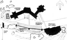
As a specific manifestation of these goals, a description and visual interpretation (Figures 3.2 and 3.3) of proposed actions is also presented in the Environmental Statement. These actions recommend following a "moderate" course of development. More restrictive as well as liberal development alternatives were also considered, but rejected as either economically infeasible or as having an unacceptable environmental impact on the site. (6) A summary of the actions proposed by the Environmental Statement is as follows:
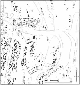
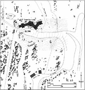
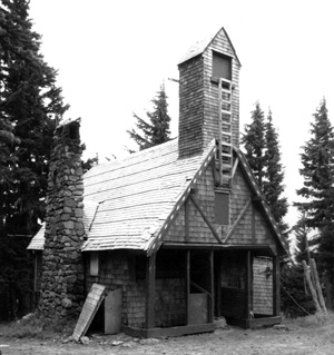
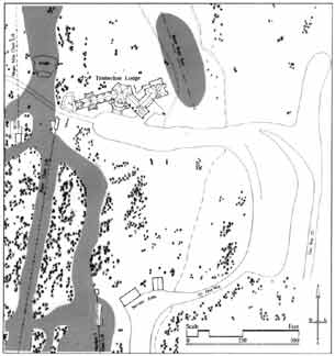
A direct connection to Timberline Lodge via a tunnel between the loading areas is also recommended. Based on these objectives, the location recommended by the Environmental Statement is site "A", "West of the Middle Parking Lot", (Figure 3.5). Other proposed actions, which would have at most only a minimal effect on the design of the day lodge, include "Support Facilities" (water, sewer and electricity), "Administrative actions", and "National Historic Site Implications". Existing Structures: All of the existing buildings on the site are to remain (Figure 3.5). Aside from Timberline Lodge and the chairlift buildings, two other structures also exist in the immediate vicinity of the site: a maintenance shed for vehicles and equipment, and a sewage treatment plant. Both are located 800 feet down the hill south of the Lodge--the sewage building to the east. The amphitheater, north and west of the Lodge, is built into the hill, and, by the time the ski season begins in the fall, is completly covered by snow. Two other structures have been built within the permit area: Silcox Hut (the old Magic Mile Upper Terminus, Figures 4.37 and 4.38, see Chapter IV), and the Phlox Point cabin (Map 3.2; Figure 3.6). Neither would be affected by, nor influence directly any other construction on the site.
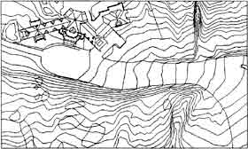
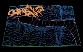
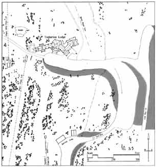
Topography: For a ski area, the average slope within the permit area is very gentle, only about twenty per cent. From Timberline Lodge, at 6,000 feet, for two and one-half miles up to about the 9,500 foot level, the steepness increases gradually, and is easily walked. Down the hill from the Lodge, more variation in the terrain is found, yeilding steeper slopes and small vales. A stream, the north fork of the Salmon River, cuts through the site between the parking lot and the Lodge, which has been easily bridged by a culvert (Figures 3.5 and 3.7; Plate 3.1).
Climate: The most characteristic thing about the weather around Mount Hood is that it is very changeable. It is rare to two consecutive days experience the same weather conditions. The climate on the whole is, however, very consistant, both in its effects and its variability. Two main seasons are experienced: summer and winter. Fall and spring are so short as to be insignificant. Snow begins to fall early in September, but usually with no accumulation until late October. Most years find enough snow on the ground for skiing by Thanksgiving--at least 30 inches. The snow pack continues to grow until it reaches its maximum, usually in March. An average winter will see over 200 inches of snow on the ground at this time. Most of it will be gone from the vicinity of the Lodge by the end of June.
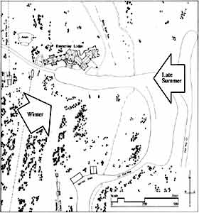
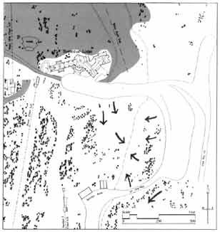
The winter storms which bring snow prevail from the southwest (Figure 3.8). Thirty mile-per-hour winds are not uncommon, but at this strength do force curtailment of operations. Storm winds in excess of fifty miles-per-hour occur only once or twice a year.(15) Strong winds from the east are also common, but do not occur as storm, per se. In the winter they bring very cold but clear and dry weather. These conditions, occurring a couple of times a year, may persist for a week or more. Winter temperatures are usually in the twenties or low thirties, with relatively little fluctuation from day to night. Not infrequently, the temperatures will cross the freezing mark in the daytime, even in the coldest months. Rain can be expected anytime. The summer is short, often lasting only through July and August. Days are warm and clear, while the nights are quite cold; a forty degree temperature swing is not uncommon. Late in the summer very warm, dry winds of up to 100 miles-per-hour may be expected. These winds often carry sand, causing localized sand storms. Flora and Fauna: Wild life at the 6,000 foot timber line is not sparse by any means. In winter, the rich variety of plant and animal life characteristic of many wilderness habitats is all but hidden by snow, making its renewed presence in summer a perennial surprise. Timberline Lodge stands on two transition lines. One line separates the dry eastern Cascades from the wet western Cascades; the other separates the heavily timbered lower slopes from the arid slopes of the upper mountain. The resulting vegetation at Timberline Lodge is arranged as stringers and clumps of white bark pine and prostrate common dwarf juniper (Juniperus communis), mountain hemlock and various true firs interspersed with alpine meadows rich with summer wildflowers. Below Timberline Lodge, sufficient water is present to perpetuate heavy stands of lupine, phlox, cat's ear, etc. East and northeast from the Lodge, the Rockland Soils support more widely scattered plants communities. Plants in this 'desert' do not form solid mats, but thousands of plants varying from tiny seedlings to hummocks 12-18 inches across dot the landscape.(16) The timber-line fauna is equally as rich; birds and mammals abound. Over sixty species of birds inhabit the area during the year, many of which are permanent residents: the raven, Clark's nutcraker, and crested gray rosy finch, for example. Indigenous mammals include the black-tailed deer, chipmunks, golden-mantled ground squirrels, chikarees, cony, and marmots. Occasionally, larger mammals such as bobcat, cougar, cayote, and raccon are seen, although rarely. No endangered species reside in or regularly visit the permit area. (17) Vehicular Circulation: Access to the site for all vehicles is via the two-lane, paved secondary road originating at the summit of Highway U.S. 26, a quarter mile east of Government Camp. One-half mile before its terminus it divides onto a one-way loop around the middle parking lot. Several gravel roads, including the Old Timberline Road can also be used, but only in the summer. Most visitors arrive by private car, although tour buses in the summer and ski buses in the winter do service the area. Timberline Lodge also operates a shuttle bus from Government Camp on a limited basis.
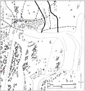
Parking, as shown in Figure 3.9, is allowed in several areas at Timberline. Designated the "upper lot", parking along the widened road in front of, and just below the Timberline Lodge is intended primarily for Lodge guests, especially when visitation is heavy. General visitor and skier parking is encouraged in the "middle lot", which is entered at its northern (upper) edge from the loop road. A guard rail seperates the western edge of the parking area from traffic exiting the upper lot or continuing past the middle lot entrance. The middle lot is exited from its lower, southern end. Additional parking areas are available when the middle lot is full. North of the loop road, what used to be parking for the Old Magic Mile lift can be used as well as the widened section of the loop road south of the service area. Snow Removal: From the first snows in September, crews work to clear snow from the roads and parking areas. Plowed snow from the upper lot is pushed over the embankment to the south, into an area which will readily accept a seasons accumulation (Figure 3.10). The loop access road and northern lot are easily cleared of snow by conventional methods into the Salmon River canyon to the east, or, when necessary, into the adjacent forests.
Snow removal from the middle lot however, is a significant problem. Only a small amount of snow can be pushed to its perimeter without impinging upon areas used for vehicular access or recreation. Snow must therefore be either stored within the parking lot itself, thereby reducing its capacity, or be pushed over the embankment into the access road to the east and from there blown in to the canyon. Both solutions are undesireable and, although it does not directly affect this project, this problem points out the substantial difficulties that can be posed by having to move large amounts of snow. (The Environmental Statement proposed building a retaining wall adjacent to the access road to solve this problem; the lot would then be enlarged so snow can be blown over the road directly into the canyon.) Recreational Facilities: Down hill skiing is the primary recreational attraction at Timberline, both summer and winter. Currently, all of the ski runs are west of Timberline Lodge, with the exception of the beginners area near the Betsy rope tow (Figure 3.11). Most of the winter skiing is down the mountain from the Lodge, on ski runs of varying terrain and surrounded by forest. The runs above the timber line, accessable from the Magic Mile chairlift, offer a contrast: intermediate skiing on gently sloping, open snowfields. The area is also lit for night skiing, which draws regular crowds. Of the five chairlifts, two have their termani in the immediate vicinity of the Lodge. Here, if anywhere, is the center of the ski area, where the majority of skiers begin and end their day.
Two other winter sports activities, cross country skiing and inner-tubing, are popular at Timberline, although no special facilities are provided for them (Figure 3.12). Most of the cross country skiers who use the area traverse the gentle terrain around the Lodge, near the forest timber line where open space is plentiful but not too exposed. In addition, two long ski trails, the Alpine and Glade trails, connect Timberline with Government Camp and are used by both down hill and cross country skiers. Inner-tubing (sliding down snow-covered hills in over-inflated truck inner tubes) happens mostly on weekends and holidays, just about anywhere near the parking lots with some slope and no skiers.
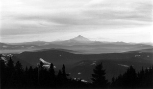
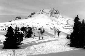
The south side ascent of Mount Hood is one of the most popular climbs in the world, drawing thousands of people, of all ages, each year. (18) May, June and July are the best climbing months, although successful climbs are made at other times of the year as well. The two most common starting points are from the Timberline parking lot, as shown in Figure 3.13. Numerous nature trails (Figure 3.13) have also been constructed around Timberline Lodge for use by guests and visitors. Day-hikers and back packers also begin their trips from Timberline Lodge. The Pacific Crest trail, which runs the length of the continent from Mexico to Canada, passes eight hundred feet north of the Lodge and forms part of the Timberline Trail, a well travelled loop trail that encircles Mount Hood. Summer or winter, skiing or walking, Nature is very accessable at Timberline. Visual Characteristics: Without a doubt, the presence of Mount Hood dominates any view of, or from the site. Whether the view is of the peak itself to the north, or of its foothills to the south, there is a constant visual reminider of one's presence on the mountain. The southern view includes a horizon that streaches from far out in eastern Oregon to the foothills overlooking Portland to the west. On a clear day, Mount Jefferson and the other peaks of the southern Oregon Cascades are visible directly to the south (Figures 3.14 and 3.15). Closer to Mount Hood, the Mirror Mountain ski area (formerly Multorpor-Skibowl) and several lakes, nestled into the foothills, can be seen. North from the Lodge, a spectacular view of the summit can be had on a clear day (Figure 3.16).
Of all those who use the Timberline Lodge Resort Complex, day-visitors far outnumber the rest. As many as 9,000 people may visit the area on a peak weekend day; 4,000 on an average day (these are 1968 figures, visitation has undoubtably increased substantially since then). (19) Non-skiers comprise eighty-eight percent of the annual visitations, (eighty percent in the winter), as most visitors come to see the Lodge and its setting. Timberline advertises itself as a winter sports complex and tends to attract people with an intrest in snow and mountain related recreation, but, with the high number of "walk-through" visitations, it is clear that presently the attraction is most often Timberline Lodge itself (Table 3.1).
Overnight guests are currently limited in number to 150 by the size of the Lodge (fifty-six rooms). As already mentioned, more rooms have been proposed to bring the capacity to at least 300. Convention facilities were added in 1974 as part of the addition to the Lodge to attract guests during the low demand times of spring and fall. Employees, for the most part are required to use overnight accommodations in Government Camp or elsewhere, to free up rooms in the Lodge for paying guests. FACILITIES PROGRAM - THE WY'EAST DAY LODGE The facilities program supplied by BOORA (Appendix C) describes a single structure approximately 40,000 square feet in size. The space requirement descriptions, divided into five broad categories, are summarized and condensed as follows (see also Table 3.2):
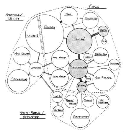
Those who drew up the facilities program envisioned the Day Lodge as essentially a large circulation space within which lodge activities would take place. "The space identified as 'Milling' . . . will function as the 'livingroom' of the Day Lodge . . . where people come in to rest and warm up and should logically function for summer and winter visitors" (Appendix C, Section 231.2.a). Another part of the circulation space is identified as more utilitarian by the designation 'Lockers'. Flexibility of juxtaposition is allowed in the realization of these two circulation requirements. All publicly accessable spaces are to open directly off the major circulation spaces. Two entries, at each end of the circulation area, are implied but not specifically required. Near one of the main entries, a VIS display is required for use by the Forest Service.
A large rental area is required to accommodate both regular ski and boot rental as well as the equipment required for the ski school Graduated Length Method (GLM) of instruction. First aid and ski patrol rooms must be near each other and and directly accessable from the outside. (It is not advisable to require the ski patrol to transport an accident victim through any of the public spaces.)
These facilities are primarily for offices and activites to be moved from Timberline Lodge: ski school, Forest Service workshops, and non-hotel administration. The employees dormitories provide overnight accommodations for up to sixteen people, most likely seasonal workers. These rooms allow some of the sleeping rooms in Timberline Lodge to return to use by guests and are the only sleeping facilities in this portion of the overall development.
The dining room and kitchen are intended to operate in a "fast food" style--limited short order with some pre-prepared items. Customer turn over is high. Peak use is on inclement weekends during lunch, around 12:30 pm. Night skiing will provide some dinner clientele, but the preponderance will be for lunch. An atmosphere "typical of a Ski-Lodge" is suggested for the beer stube. It should include the bar, but emphasis is less on alcohol consumption (limited to beer and wine) and more on "apres-ski" socializing.
The loading dock is the focus of all the utility and service oriented spaces. Aside from normal deliveries, it will probably have to serve as one of the primary fire exits, thus be accessable to the interior public spaces. It must be enclosed as it serves the first aid room and attending ambulance during inclement weather. Mechanical facilities will likely include heat generating equipment for both the Day Lodge and Timberline Lodge, pending the outcome of an evaluation of the existing boiler system. A service tunnel between the existing loading dock in the 1974 C. S. Price convention wing addition and the new Day Lodge mechanical spaces is also suggested.
A space relations diagram is shown in Figure 3.17 which reflects the requirements of the facilities program. The two entries, implicit in the program, are included as end points of the public circulation system and are shown shaded.
Go to CHAPTER IV - SITE HISTORY: BUILDING ON MOUNT HOOD CHAPTER III NOTES 1. U.S. Department of Agriculture, Mount Hood National Forest, Timberline Lodge: Final Environmental Statement, (1975), p. i. (Hereafter cited as Environmental Statement.) 2. Ibid, pp. 5,8. 3. Ibid, p. i. 4. Ibid, p. 15. 5. Ibid, pp. 42-68. 6. Ibid, pp. 15, 16. 7. Ibid, p. 18. 8. Ibid. 9. Ibid. 10. Ibid, pp. 17, 18. 11. Ibid, Appendix 1. 12. Ibid, Appendix 2. 13. Ibid, Appendix 5. 14. Ibid, Appendix 3. 15. Bill Connerly, Timberline Lodge manager, telephone interview, December 9, 1984. 16. Environmental Statement, p. 6. 17. Ibid, p. 6. 18. "After Mount Fujiyama in Japan, Mount Hood is often called the most often climbed glacial mountain peak in the world." Carl Gohs, Timberline, (1973), p. 10. 19. Environmental Statement, p. 8. Master of Architecture Thesis | ||||||||||||||||||||||||||||||||||||||||||||||||||||||||||||||||||||||||||||||||||||||||||||||||||||||||||||||||||||||||||||||||||||||||||||||||||||||